Landslides, Spirits and Stories: Science and myths surrounding a mega landslide in the Himalayas

Written by Parineeta Dandekar. Photographs by Abhay Kanvinde.
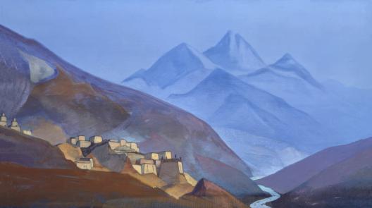
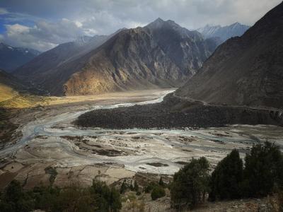
Photo caption: The plains and mountains of Bhaga Basin. Photo: Abhay Kanvinde.
Here, in this central spot where three valleys come together
Is the triangle from which all phenomena originate,
An abode of the yoginis of the past,
A place for practitioners in the future.
~ A Tibetan prayer to the sacred Drilbu Ri Mountain where Rivers Chandra and Bhaga meet to form the Chenab
On a crisp September morning, we clank across an iron suspension bridge on the River Chandra to enter the valley of the Bhaga. We are tracing the origins of Bhaga and will be reaching Barlacha La pass at an altitude of 15,900 mts. Madly fluttering prayer flags festooned on the shaking bridge and the roaring river below make it seem as if, like the prayers, we are rapidly adrift too. Below, on the toasty river sands, a few men doze in the sun like monitor lizards.
“We are entering Punan valley from Tinan valley. Chandra is Tinan valley or Rangoli, Bhaga is Punan valley or Gara and after the confluence, Chandrabhaga forms the Pattan valley” says Virendra. Virendra, like most of our friends in Lahaul has a Bodh (Buddhist) name and a Hindu name. He is both Virendra Katoch and Kesang Dorje, his son Raghav is Tenzin Tobgyel and his daughter Neha is also Yangchen Choden. The dashboard of his car has an image of Shiva and Buddha. Nothing of this seems special to him. Deep syncretism is a way of life here, has been so for centuries.
Lahaul, that vast, sparsely populated region in the north-eastern corner of Himachal Pradesh is a magical land. Encompassing parts of the Tibetan plateau and the High Himalayas, Lahaul was once known as Garsha Khandroling or the Land of Dakinis (female spirit guides). The entire landscape encircled by the Himalayas with just four high mountain passes in each direction, marked with the sacred mountain of Drilbu Ri overlooking the confluence of Rivers Chandra and Bhaga, has been equated to a tantrik Mandala, a symbolic representation of the cosmos.
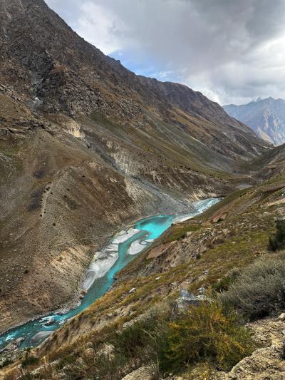
Chandrabhaga or River Chenab, the largest tributary of River Indus, is created by the confluence Chandra and Bhaga. While Chandra emerges from the cerulean glacial lake of Chandratal, surrounded by folktales of fairies and shepherds, Bhaga rushes from the upstream of Surajtal, amidst the shadows of the Barlacha la Pass. While Chandra’s valley is claustrophobically narrow and dramatic, with some of the largest glaciers in Himalayas, Bhaga’s valley is gentler, more expansive, dotted with villages and farms.
The road from Tandi to Barlacha la Pass is an ancient trade route, used for centuries by travelers from the plains of Punjab to reach the stark plateaus of Ladakh and Tibet. This land, shared with snow leopards and Himalayan Ibexes, was one of the secondary routes to the Silk Route. On the left are steep mountainsides and on the right is the constant roar of the lapis-blue Bhaga. The river is so startlingly blue that I think of a tracer dye I once used to check groundwater infiltration leaking into the river somehow.
We cross the bustling town of Keylong, Lady of Keylong glacier, Shashur Gompa and its starkly imposing sacred grove. We meet dramatic personalities like Rigzin Hyrappa who talks about flowing rivers and dam protests, Thinlay Shastri who talks about melting glaciers and the region’s syncretic history. We pass several camps jostling with the riverbanks, mules laboriously carrying potato sacks on their backs, weather-beaten and burnished men and women, hauling up produce from deep river valleys on creaking pulleys. Poplars and Birches have turned a bright turmeric yellow by now. Only Cedars and Junipers stand erect and green against the purple mountains.
Darcha Maidan and the landslide that shimmered
And just as we reached the village of Darcha, the last permanent settlement in Himachal Pradesh, the last settlement also for the cedars and sacred junipers, we see a huge, tumbled mass of blue-black angular boulders, shimmering like obsidians in the dimming light. It looks otherworldly, as if the mountain has somehow spilled its secrets before us. As we maneuver the bend, we see the spill spread languorously across a vast open space. And ‘vast’ in the High Himalayas is very different from vast anywhere else.
This plain is the fabled Darcha Maidan (Darcha Plains), a floodplain perched at an elevation of 3360 meters, where three rivers meet: the Bhaga coming from Baralacha La pass, Jankar Chhu from Zanskar Ranges and Melang from the Mulkila Ranges. After a steep and narrow course, the rivers suddenly spill and slowdown in this expanse, like a person heaving a sigh of relief after a brisk run.
Such river-plains are possibly some of the most beautiful places in a river’s journey. Like Dibang at Nizamghat, Lohit at Parshuram Kund and Siang at Pasighat.
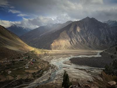
The sand across the landscape is gold and the waters are a frenzied mix of turquoise and jade. The angular boulders from the huge spill have visibly pushed the confluence aside. I tell Abhay that this must be a recent landslide, judging by the shiny, angular surfaces and sharp edges of the rocks.
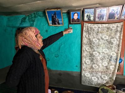
After crossing two rivers we reach Darcha, which faces the landslide, to meet the feisty Sonam Dolma who spearheaded the women’s protest against 300 MW Jispa Hydropower Project. In one of the most remote permanent settlements in the world, women marched to show their anger against a project that was set to submerge their homes. Sonam was the Pradhan (Head) of the Darcha village then.
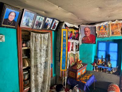
She now stands in her front yard, hand on her hips, with the mighty confluence as her backdrop. She invites us inside her home, a traditional green Lahauli mud house, with a low roof, thick mud walls and a hearty tandoor (hearth). We sit cross-legged around the hearth and munch on home-grown plums. From the altar, several Buddhist deities smile at us. Sonam has been the village Pradhan for several years and tells us how she organized the women to “drive away” the dam officials. She beams at our shocked faces. She says she loves it here. “It is not too hot, nor too cold. We have all the medicine we need from the trees around us. We plant our potatoes, have plums and apples and barley. We have a community to sing, dance and occasionally, to fight. We have a school and good, cold water. How can we leave all this and shift to a place we hardly know?”
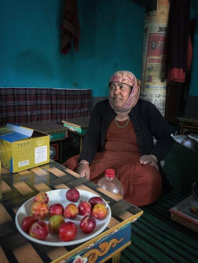
Her brave, weather beaten face shows signs of fear at the mention of moving. “We will not let anyone drive us away. The women won’t. It is too hot in the plains for us. We cannot survive there.”
Hubris of an entire village and an old Lama
We talk about dams, rivers and the unbelievably hard and full life in Darcha. As we say goodbye and promise to return a hostel she is building for intrepid travelers, Abhay catches a sight of the boulders strewn across the opposite bank, in the last rays of the sun they look auburn. It’s a mesmerizing sight.
“When did this landslide happen?” asks Abhay
I am expecting she will say last year. Or maybe two or three years back.
Sonam says, “This is ancient. Several hundreds of years old. Story goes that there was a village there, at the confluence. Once at a village feast when everyone was making merry and drinking chhang (local beer), an old man appeared in tattered clothes and dusty feet. No one paid any attention to him, nor did they offer him food. The old man stood forlorn in a corner. Then a kind young girl saw him and offered him her seat. She fed him and talked with him for a while. To her surprise, the old man suddenly picked her up and hurled her across the river! That’s here in Darcha! The old man was a magical Lama. Seeing the hubris and arrogance of the villagers, he was enraged, and his wrath caused the mountains to split and gobble the village. The girl, who reached the safe bank, started a new family in Darcha. We are her descendants!”
We were fascinated by the story. And I was more than a little embarrassed knowing just how wrong my age estimate was.
I was to be embarrassed further.
Who is the oldest of them all?
After coming back, I began putting together reports on climate change, flood disasters and landslides in Lahaul. The region is facing severe impacts of climate change with nearly all glaciers receding and frequency and intensity of landslides, floods and disasters increasing. I came across a 2009 paper, “Nature and timing of large landslides in the Himalaya and Transhimalaya of northern India” by Jason Dortch, a geologist from University of Cincinnati, Ohio and his team. The paper dealt with several ancient landslides in the Himalayas and specifically, of a landslide near Darcha. I put the coordinates on Google Earth to check out the location. It was precisely the site where the glistening boulders lay facing Darcha!
So, this was the hundreds-of-years-old landslide which ate up a village. The paper had dated the landslide approximately. It was about…I could not believe my eyes…The age of the landslide near Darcha was pegged at approximately 6000-7000 years ago!
According to the authors, Darcha landslide is made up almost exclusively of phyllite blocks which fit into each other like pieces of a jigsaw. Phyllite is a typical metamorphic rock found in the Himalayas, it is halfway ahead of shale and on its way to became gneiss with increasing pressure and heat. The stone is flaky with lots of mica and is the shiniest amongst metamorphic rocks. No wonder the boulders shimmer in moonlight and are said to change color in the day: rust red in the morning and nearing starry blue as the night approaches.
The scar of the landslide is high up in the mountain at around 4000 mts. The sheer volume of the slide is about 10 million cubic meters, volume enough to fill 4000 Olympic size swimming pools. The reason behind Darcha landslide is not glacial buttressing but a mix of seismic activity and “gravitationally-induced buckling of the slabs.”
The age of the landslide was calculated by beryllium 10 dating method which in itself is fascinating. From the little that I understand, Beryllium-10 is produced on the Earth's surface when cosmic rays interact with oxygen and nitrogen in the atmosphere. The amount of Beryllium-10 accumulated on a rock's surface is proportional to how long it has been exposed to cosmic rays. By measuring the concentration of Beryllium-10 in a rock and knowing its production rate, scientists can calculate the rock's exposure age.
The surface of the boulders is covered with crumbling patches of map lichen (Rizocarpum geographicus), one of the oldest living species in the world, with estimated ages reaching 8000 years!
The scientific tale of the landslide is as stunning as the lores surrounding it.
From then on, I kept stumbling upon mentions of Darcha landslide in the books on Lahaul.
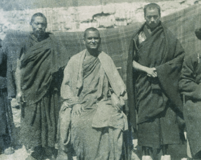
Rahul Sankrityayan and Zimug Sringpo
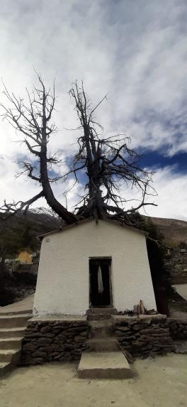
The great scholar, polymath and iterant traveler Pandit Rahul Sankritayan was intrigued by the Darcha Landslide too. He witnessed it during his unbelievable travels from Ladakh to Lahaul in the 1930s. In a letter written to his friend Anandji in October 1933, Pandir Santriayan narrates the folktale Sonam told us and wonders if the part about the village being engulfed by the landslide maybe a relic of a historical happening. He mentions stunted Devdar (Cedrus deodara) trees growing amongst the rubble. 90 years later, the trees remain stunted, as we witnessed.
In 1924, Hugh Whistler, a strange mix of a Police Officer and an expert Ornithologist, who put together one the first guidebooks on Indian Birds, wrote about Darcha in his delightful book, In the High Himalayas, “Just before Darcha bridge is reached, the road leads over a huge landslide, which projects right into the bed of the rivers, a tangled mass of mighty splinters of rock which most clearly came from a great scar on the mountain above. Tradition relates that a whole village lies overwhelmed underneath this spot. There was one survivor, who was blown out of the village and thrown across the Bhaga to the flowery slope opposite.”
In his fascinating Himalayan Wonderland: Travels in Lahaul and Spiti (1972), former Chief Election Commission of India (late) M.S Gill narrates several lores about the landslide. In his narration, the Lama hurls the house of the family that helped him across the rivers to Darcha. The family is still known as Lungpa Chanpa: meaning the family of the house that flew!
He tells of how the spirits of the people killed in the landslide coalesced into a malevolent-but-funny mega-spirit called Zimug Sringpo. A trickster like Loki, Zimug Sringpo is the undisputed king of the Darcha Maidan. He lures travelers, threatens Lamas and eats up the sheep. It is said that in 1890, to contain Zimug, a valiant Lama tied him up to a pole in the middle of the floodplain. The lama was none other than the Abbott of the fabled Hemis Monastery from the banks of Indus in Ladakh. But Zimug Shringpo keeps fighting against his chains and villagers and travelers have to be vigilant about the spirit, lest he escapes.
These allegorical tales get more embellished over the years. Sometimes, they lead to hilarious happenings. Once a Lama travelling in the night mistook a police constable for Zimug Sringpo and pelted him with stones. The Constable, in turn mistook the shower of pebbles as a sign of Zimug Sringpo and charged at the shadow with a stick. Thoroughly convinced and thoroughly scared, they both tumbled into a stream!
Thinley Shastri tells me that tales of Zimug Sringpo colored the valley till date and when the Border Roads Organization cut through the valley to build a smooth road, Zimug Shrigpo tried all the tricks in the (his) book to derail the project.
But just as the tricksters, the land is also protected by benevolent nature spirits, known as Dharampals or protectors of the realm. These Dharampals ome in many forms: that of Chortens (small Buddhist shrine) on the high mountains, and also as sacred trees known as Shungma. A lone Juniper tree ( Juniperus polycarpos C. Koch, J. indica Bertol. and J. communis L. var. saxatilis (Pallas) are the Junipers found in Lahaul) stands on the roadside on the way to Darcha, swaddled with white silk scarves, encircled in a small shrine of its own. Thinley Shastri says. “This tree was supposed to be uprooted, but several mishaps happened along the road and finally the plan of uprooting was dropped by the Border Roads Organization. Across our lands, several sacred signs guard us. Jispa Hydropower Project will submerge the land of our ancestors. Just as our farms, these signs hold meaning for us. They are important.”
Making sense of our world
Across the world, native societies have tried to make sense of their world through the tools available to them. Societies, modern and ancient, connect human tragedies and celebrations with their environment. Dramatic geological happenings have been woven into folktales world over. In the Northeastern Indian State of Nagaland, Natsumi has a beautiful story about a major landslide in their village, Salish people in the State of Washington have startling stories around earthquakes and landslides. Some stories of more recent landslides may also provide us with clues to know more.
Interpreting the natural world through multifarious lenses of science, art, history, culture, even conflicts, has been a trait of societies. One does not negate the other but adds richer layers of meaning to the phenomenon. In the tales surrounding Darcha Landslide, we have the privilege of witnessing both: organic stories of love, fear, and awe as well as objective quest of science, equally driven by curiosity and wonder. To think that this confluence of sorts is happening at a real river confluence in a remote corner of the world makes it more breathtaking.
300 MW Jispa Hydropower Project
Darcha Maidan, a storied, precious place, a Triveni (trijunction) where three rivers from three towering Himalayan peaks meet, home to Sonam Dolma and her friends and family, home to the spirit of Zimug Shringpo, sacred Junipers and chortens and home to a landslide that tells the ancient story of Himalayan geology, is set to be submerged under the 300 MW Jispa Hydropower Project.
Just like the landslide once did, the dam too proposes to eat up the village along with 4 other, Sonam’s old home, their pastures and hardworking farms. Its tunnels, over 15 kilometers long, dug under the fragile Himalayas will disrupt the homes and water supply of several villages. Jispa hydropower project proposal has been changing hands from one powerful investor to the other. Once operational, its electricity will be fed in the grid and will power factories and cities far away. Now with Indus Water Treaty in shambles and a race to impound rivers of the Indus basin accelerating, one fears for Darcha and River Bhaga.
However, one should remember that Darcha Maidan is a place where once an old and poor Lama unleashed his wrath towards the hubris and arrogance of the people in power.
Some stories are truly allegorical.