A Sinking Village and a Stream that Floods in the Sun: Climate Change, Jahlma Nallah and Lindur

At the village of Jasrath in Lahaul and Spiti, the River Chandrabhaga’s current is swift and strong like a rambunctious toddler. The river is new here, birthed just 16 kms upstream at the confluence of the Rivers Chandra and Bhaga. Chandrabhaga will be named as Chenab only after a journey of about 400 kms downstream. Chenab is one of the largest tributaries of the River Indus whose expansive basin feeds over 250 million people in the heart of Asia.
Lahaul and Spiti district in the state of Himachal Pradesh is a cold desert with very little rain, but the narrow ribbons of land along the Chandrabhaga are emerald with willows, apple orchards and cultivated farms. This is precious land.
We are traveling along the Chandrabhaga, stopping at villages like Tandi, Tholang, and Jobrang, listening to the stories of wiry farmers, sheep herders, weavers, and orchard owners. Tales of drying springs, late snowfall, treacherous floods, and landslides are immutable around us. This valley called ‘Pattan’ is framed by steep Pir Panjal cliffs on both sides. Mountain goats and snow leopards roam these slopes in winter. Glacier-fed Nallahs (streams) rush from the cliffs and dive into the river angularly without forming silt-rich mouths. Purple mountains bear unmistakable open scars of landslides.
The Sinking Village
We turn to the right and creep up a cliff towards a small village called Lindur. On our left is a glacial stream with extremely steep sides called Jahlma Nallah. Situated at an altitude of 3328 meters, the only source of drinking water and irrigation for Lindur is the glacial melt of Jahlma Nallah.
A curious, foreboding rumble accompanies our ascent. A pack of mules runs ahead of us, their hoofs clanking on the cobbled path, raising a cloud of dust. As we reach Lindur, the pack moves away but the cloud does not dissipate, nor does the sound dampen. It is then that we realize that the dust is rising from a gorge ahead. Just like the low rumbling.
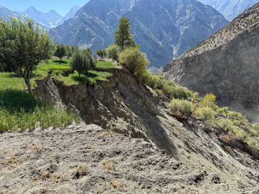
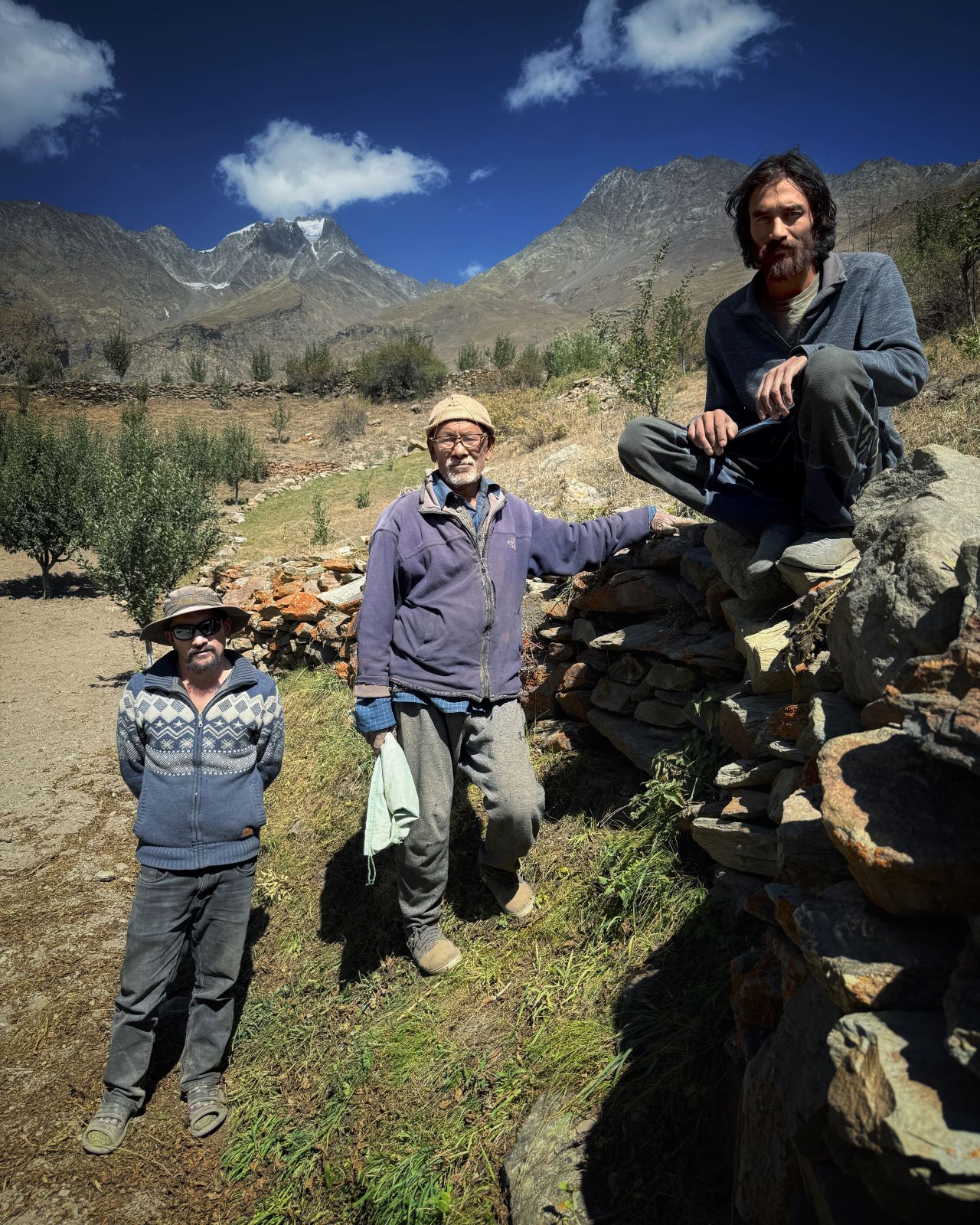
“This keeps happening here,” said Devi Singh ji, 74. He is waiting for us under an apple tree laden with fruits. He takes us to the banks of the gorge. After a few sure-footed steps, we come to an abrupt halt: a chunk of the orchard is simply sliced off, like a cake cut in a hurry. Several apple trees lay mangled in the gorge of Jahlma Nallah, still holding on to their pink bounty.
Dust clouds arise from the Nallah and we realize where the rumbling comes from: the entire slope is in motion. Stones roll down, gathering strength and taking more stones, trees, and soil with them. The sides show small trickles of water.
This is an active landslide. Jahlma Nallah is eating away at the village.
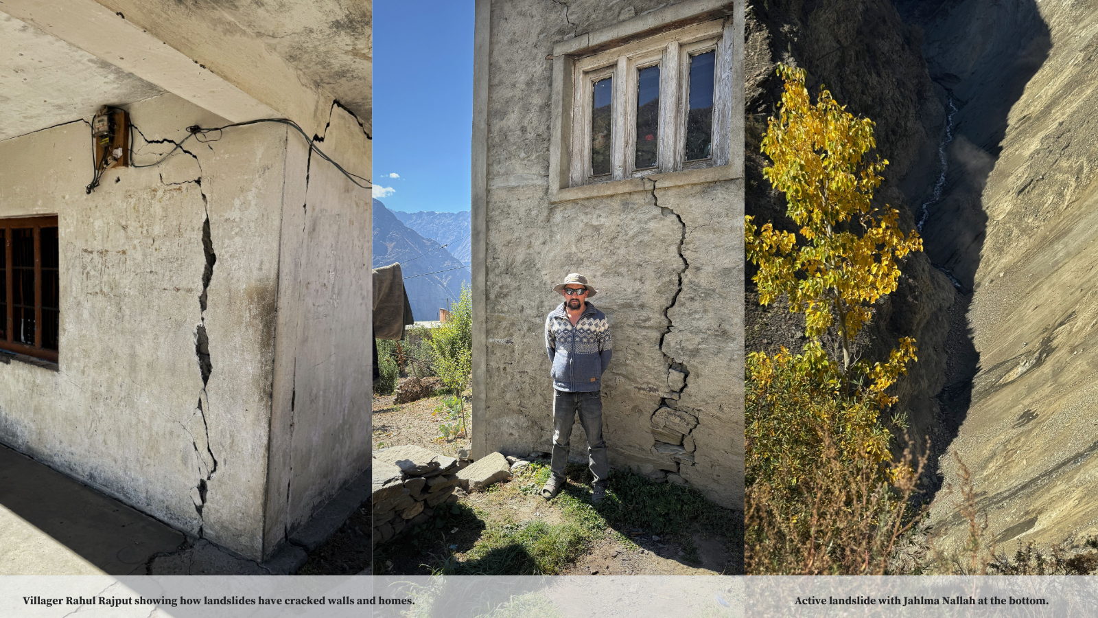
Landslides have claimed more than 30 acres of cultivated land of Lindur. The entire village is covered with cracks, which transform into foreboding gaps near the Nallah. Almost all of the 70 homes in the village, old and new, show signs of cracking. Walls stand separated from their columns; door frames hang on without support. A solitary stupa which marked the presence of this remote village has collapsed.
Small landslides along the glacial stream started around 2000 but during the uncharacteristically heavy monsoon of 2023, Jahlma Nallah roared and ate away parts of its banks and it is then that the landslides and cracks accelerated and became unstoppable. The villagers are scared and confused. They do not have clear answers as to why this is happening and what they should be doing.
Villagers surround us thinking we have some answers, and we return their dismal glances. Women, men, youth - all have a story to tell, a home to show, a field to take us to. A political leader from Lahaul has been discussing relocating the entire village, but the plans are not yet clear. Devi Singh ji shows us the glacier atop Lindur. People around us nod in agreement. This part of the puzzle is extremely important, as we realize later.
"Where can we go? Our home, our things, our animals, to leave all this behind and go is very difficult. We were born here, how can we go elsewhere? Its become very difficult for us. What government can do, we don’t know. Glaciers in the back have shrunk, have seen it with our own eyes. Have gone up many times, about 10 years back, when I was stronger, I could walk up there. What can we do?”
“This glacier dried up before my eyes," said Singh ji. "When I was in my thirties, we used to have 5 to 6 feet of snow in the winters. In March before sowing, we had to spread mud over the ice to make it melt faster. I do not remember doing that in the last 10 years. Now the snow comes late, not in December but in February and then melts away sooner. In the summer months, Jahlma Nallah floods without fail even when there is no cloud in sight.”
“Jahlma Nallah flooded several times last year" said Rahul Rajput, a young apple farmer. "Not only when it rained, it used to flood thrice a day even when there was no rain in sight.”
“We saw scientists climb up the glaciers," said Parbati Devi. "Our sons went with them. We were told that our village is situated on soil heaps left by glaciers. But we don’t know what exactly is happening or what we should be doing.”
Climate Change Affecting a Rock Glacier
Scientists from Indian Institute of Technology (IIT) at Mandi and Geological Survey of India (GSI) have visited the place. But the villagers have no clear answers.
Report by IIT Mandi, “A Preliminary investigation report On The subsidence happening in the Lindur Village, Lahaul, Lahaul & Spiti, Himachal Pradesh” does not mince words when it states that glacial melt from the Jahlma Nallah is one the primary reasons behind the repeated landslides and cracks. According to the Report, Lindur is situated near a crack which is developing close to a ‘Rock Glacier’ (A category of glaciers constituting of debris, rock, permafrost with less than 45% ice. These slow-moving glaciers are susceptible to changes in temperature and are an indicator of climate change.)
Lindur’s temperature between 1950 to 2023 shows a remarkable upward trend for all the three months of June, July and August with notable warming in July. Trends also show increasing precipitation, increasing soil temperature, while decreasing snow accumulation in July between 1950 to 2023. All of these factors result in accelerated melting of ice in the rock glacier.
The report by IIT Mandi demonstrates a direct and clear link between rising temperature and increasing risk to life and property at Lindur. This also corroborates with multiple studies about glacial melting and changing temperatures in the headwaters of Chenab basin due to climate change.
Post disaster study by Geological Survey of India carried out in October 2023 which recommends rehabilitation of the affected homes to a safer area states, “The entire Lindur village is situated on an unconsolidated debris material with multiple crack sets towards the glacier snout zone indicating that the entire area is situated on an unstable slope and any triggering activity in the form of excessive glacier melt or cloud burst event, where, the ground becomes oversaturated, can lead to slope instability.”
Scientists saw slope failure and active landslide in the Jahlma Nallah during their site visit. “The fact that the landslide is active during the time of visit i.e., non-monsoon period indicates that seepage of glacier melt water and channelized nala for irrigation as contributing factor for the slide together with the type of slope forming material.”
Curious Flooding of the Glacial Jahlma Nallah
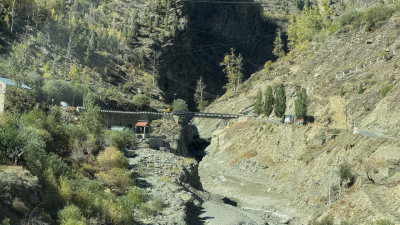
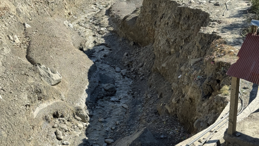
Jahlma Nallah which arises from the glaciers of Lindur and flows down steeply to meet Chandrabhaga has been flooding catastrophically for the last 4 consecutive years, eroding its banks and blocking the flow of the massive mainstem of Chandrabhaga River itself.
For a Nallah with a watershed of barely 33 sq. kms, this is unprecedented and indicates the ferocity and the volume of flow.
In August 2021, the region experienced a major landslide following floods in Jahlma and neighboring Shansa Nallah which blocked the flow of Chandrabhaga River mainstem for hours, submerging orchards and homes in villages like Jasrath and Jobrang. The photo at right shows a bank cutting of Jahlma Nallah in the downstream.
Again, in August 2022, Jahlma Nallah flooded causing mainstem Chandrabhaga to be dammed for more than 6 hours. The scenario was repeated in 2023 and again in 2024, when Jahlma Nallah flooded catastrophically, washed away roads and bridges and claiming more than 30 acres of orchard and farmland from the villages of Jasrath where Jahlma meets Chandrabhaga.
Devi Singh jee says that the Nallah raged not only because of precipitation but “because it is melting itself.” We heard this repeated by several residents including Rahul Rajput.
The video to the left was published by local news media and shows a raging Jahlma Nallah in the absence of rains. Source: Amar Ujala News Media.
The report "Why Melting Glaciers are causing both Droughts and Floods in Himalayas" quotes Rajan Parsheera, resident of Rangbe village 10 kms from Jahlma Nallah,
“These floods are not linked only to rain, and they occur even when there are no clouds in the sky. Rather, they often occur on afternoons that see a higher temperature. While there are Nallahs in Lahaul where such flash floods have been happening for years, Jahlma is not one of them. Before last year, neither had we ever seen the Jahlma Nallah witness a flood, nor have we heard about it from our ancestors. The same is the situation with the next Nallah, Shansha, where a flood occurred for the first time last year.”
This is an unprecedented and an important piece in the puzzle. Why is Jahlma Nallah flooding when there is no rain? Is it due to accelerated melting of ice in the rock glacier or somewhere else?
The reports from IIT Mandi or GSI do not refer to the repeated catastrophic flooding of Jahlma Nala and its links to Lindur landslides and cracks. This may be because the destruction that occurs at the mouth of Jhalma Nallah or the blockage of Chandrabhaga is at a lower altitude than Lindur, in edifferent villages. But it is the same watershed of Jahlma Nallah: A glacial stream affected by climate change.
According to studies, landslides on the opposite banks of Chandrabhaga may also be caused by toe-cutting of the mountains due to the ferocious floods from Nallahs like Jahlma. This is known as Confluence effect.
About 3 kilometers upstream of the confluence of Jahlma Nallah and Chandrabhaga, 130 MW Rashil Hydropower Project is planned and about 13 Kilometers downstream, 175 MW Bardang Hydropower Project is planned. Large Dams which involve blasting, tunneling and water impoundment at the precise location affected with landslides and devastating floods will add further disaster implications for the communities.
A melting glacier, warming climate, changing precipitation patterns are affecting Lindur and five villages in the watershed of Jahlma Nallah. Similar events maybe happening in neighboring Nallahs like Shansa and they need to be linked. For this to happen, it is important to understand and respond to the lived experience of the people living on the banks of Chandrabhaga in Lahaul and Spiti.
Rahul has built a brand-new home in Lindur and his mother invites us inside for a round of tea and snacks around a warm tandoor. For Rahul and his family, it is incomprehensible to think of moving. As we leave Jahlma village, Parbati Devi waves us goodbye.
“I am scared of one more flood. It might be good to leave, but our lives are here.”
by Parineeta Dandekar
Photos and videos by Abhay Kanvinde